The hostilities on the territory of Ukraine cause both direct and indirect, often delayed damage to the population, economy, and environment of Ukraine. As of January 2023, the damage caused to Ukraine’s environment as a result of Russia’s armed aggression was estimated at $46 billion. The bulk of this damage that has been calculated is air pollution ($27 billion), while soil pollution was previously estimated at $18 billion. Almost a third of Ukraine’s forests have been damaged, with at least 23,300 hectares of forest completely burned. However, all these estimates are very approximate. It is currently impossible to determine the exact amount of damage from the destruction of flora and fauna, from water pollution and soil damage. This requires preliminary detailed research on resource inventories, changes in their quality, and loss assessment. How the war in Ukraine will affect global climate processes is unknown. The established balance of greenhouse gases in the atmosphere has been disrupted, particularly due to the emission of huge amounts of carbon from fires.
Ukrainian farmers will also face significant challenges. After all, damage to fields as a result of enemy shelling is not just a mechanical obstacle to tillage; it is soil contamination, reduced fertility, and, above all, mine danger. According to studies conducted in war zones around the world, 10 to 40% of fired shells and bombs do not explode for various reasons and remain in the city of “arrival” with the possibility of detonating at any time, either from mechanical impact or even under the influence of electromagnetic waves from a regular smartphone.
It is the existence of life-threatening danger during field surveys, the need to quickly obtain a large amount of spatial information, and the need to take into account the temporal dynamics of damage that makes the use of remote sensing and GIS technologies indispensable for recording the effects of hostilities and assessing the damage.
Within the framework of the Initiative for the Development of Environmental Policy and Advocacy in Ukraine, implemented by the International Renaissance Foundation with financial support from Sweden, the NGO Society for Conservation GIS Ukraine is implementing a project to record the damage caused by the hostilities in the Kharkiv region.
With the help of detailed spatial and temporal monitoring of the territory using Planet satellite data for the period from February 24 to October 16, 2022, spatial fixation of damage caused to natural complexes and agricultural lands in the Kharkiv region as a result of Russian military aggression was performed.
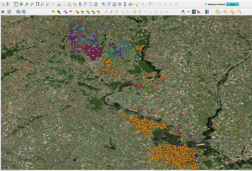
Creation of a vector layer of detected bomb craters
A spatial database of detected damage to the territory was created, which includes more than 60 thousand points and is the basis for mapping the extent of damage to the territory. This makes it possible to assess the existing mine risk and the risk of contamination of the territory and water sources, identify the most damaged areas requiring reclamation, and plan actions for demining, using, and restoring the disturbed land.
Maps of land damage and pollution hazards have been created for all affected districts of Kharkiv Oblast and can be created upon request for each interested community. In particular, we have provided such maps as part of our cooperation and information support to the Rohan village military administration.
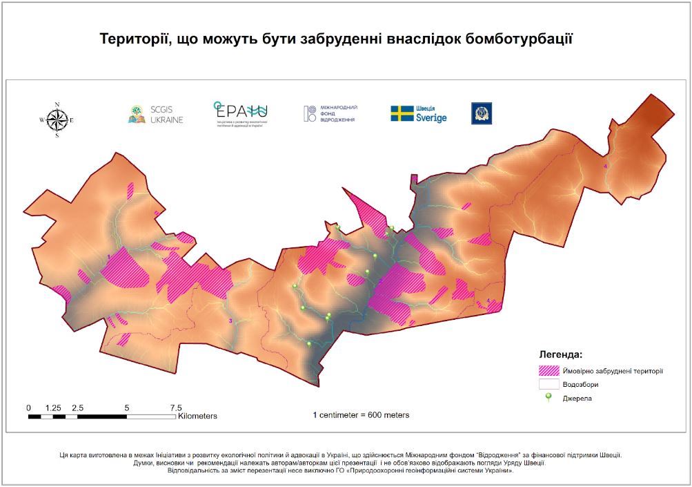
Maps of land damage
While working on the project, we improved the methodology for deciphering the damage to natural and agricultural landscapes due to hostilities using satellite imagery. A training webinar on deciphering the effects of hostilities is planned.